


Most Dangerous Diving Spot in Texas

Jacob's Well is one of the longest underwater caves in Texas. From
the opening in the creek bed, the cave descends vertically for about ten
meters, then continues downward at an angle through a series of silted
chambers separated by narrow restrictions, finally reaching a depth of
forty meters.
Through the years, many have successfully
explored the first and second chambers of the well. The first chamber is
a straight drop to about 30 feet; then it angles down to 55 feet.
Nourished by the rays of sunlight that penetrate the crystal water, this
cavern area is bright and is home to algae and wildlife. The second
chamber is a long funnel to 80 feet, where there is a restricted opening
to the third chamber. Inside the second chamber is a false chimney,
which appears to be a way out of the well but has trapped at least one
diver. The third chamber is a small room with a floor of unstable
gravel. Divers must inflate water wings to navigate this chamber
successfully, trying not to stir up silt or dislodge the gravel.

The
passage into the fourth chamber is very tight. The few who have seen
the fourth chamber say it is "virgin cave" with fantastic limestone
formations and no gravel. Covering the bottom is fine silt that can
totally obscure vision when kicked up by one misstep.
Ironically,
there was a time when it was impossible to descend into Jacob's Well.
"There's a picture of me at 3 years old at Jacob's Well in the family
album," recalls 79-year-old historian Dorothy Wimberley Kerbow. "My dad
would throw me into the well. You couldn't sink down because the spring
would just bubble you up with such force."
Kerbow recalls that
she and her friends would often visit Jacob's Well in the 1950s, and it
was impossible to go more than two feet below the surface due to the
force of the spring.
In 1924, Jacob’s Well was measured to have a
flow of one hundred and seventy gallons per second (six hundred and
forty liters per second) discharging water six feet into the air. Over
the years, the well’s flow had diminished allowing divers to reach the
deepest chambers. The spring ceased flowing for the first time in
recorded history in 2000, and again in 2008.
The first time the
spring stopped flowing, the event was considered by many as symbolic of
the region's increasing water shortage and quality problems. “It was a
wake-up call for everyone,” recalls landowner David Baker. “We don't
want it to turn into Jacob's Cave."
David Baker has given up his
home to form the Jacob’s Well Natural Area to restore and protect this
sensitive area for future generations.


Source : Amusing Planet
Ward Charcoal Ovens of Nevada

Ward Charcoal Ovens are a collection of six 30 feet high, beehive-shaped
charcoal ovens located inside the Ward Charcoal Ovens State Historic
Park in the Egan Mountain Range approximately 18 miles south of Ely in
Nevada, in the United States of America. Between 1876 and 1879, the
Charcoal Ovens were built to produce charcoal from pinyon pine and
juniper. After their function as charcoal ovens ended, they served
diverse purposes, such as sheltering stockmen and prospectors during
foul weather and even serving as a hideout for stagecoach bandits. Today
they're the main attraction in Ward Charcoal Ovens State Historic Park.
The ovens take their name from Thomas Ward who founded a local mining
district in 1872. The mine produced go
ld and silver ore that required
high burning temperature that can only be provided by charcoal,
inspiring the construction of the ovens in the mid 1870s. The parabolic
shape of the beehive ovens caused heat to be reflected back to the
center where the wood slowly burned to produce charcoal.
Each of
the six ovens stood thirty feet tall and was twenty-seven feet in
diameter at the base. The walls are 20-inches thick, made from rocks
with three rows of vents. Wood was cut into 5-foot to 6-foot lengths and
stacked inside the ovens vertically using the lower door. The loaded
oven was ignited and the metal door was cemented shut. It took 13 days
to burn and empty a 35-cord (one cord is 4-feet high by 4-feet wide by 8
feet long) kiln.
Eventually, charcoal ovens were phased out by
the discovery of coal, by depleted ore deposits, and by the shortage of
available timber.
The technique of burning wood to produce
charcoal can be traced back to traditional Old World practices.
Centuries ago, woodchoppers found that slowly burning timber in an
oxygen-starved environment produced charcoal, which was easier to
transport and burned at a higher temperature than wood. Charcoal
production was especially common in the Alps, in Scandinavia, and in
Eastern Europe. Charcoal burners traditionally used shallow pits without
the benefit of permanent structures.


Immigrants brought the
technique of charcoal burning to Nevada mining districts where it was
particularly useful when milling stubborn ore bodies that required high
temperatures. The charcoal burners consumed pinyon and juniper, which
was of little use for building or for mine supports. The industry earned
a place in Nevada history with the famed Charcoal Burner's War of 1879,
when Italian and Swiss immigrants fought wealthy mill owners of the
Eureka Mining District to the east of the Ward mines.
After
suffering from vandalism and natural erosions, the long-abandoned ovens
became a state park in 1957. These Ward ovens are the best-preserved of
their kind in Nevada.
source : Amusing Planet
Island Dubai “The World” Artificial Archipelago

The World Islands is an artificial archipelago consisting of about
300 small islands constructed in the rough shape of a world map, located
4.0 kilometers off the coast of Dubai, United Arab Emirates. The
islands are composed mainly of sand dredged from Dubai's shallow coastal
waters. 321 million cubic meters of sand and 31 million tons of rock
were used to build the islands that cover an area roughly 6 by 9
kilometers, and is surrounded by an oval-shaped breakwater island. The
islands, which are named after countries such as Great Britain, Germany,
Switzerland, etc., themselves range from 14,000 to 42,000 square meters
in area and located roughly 100 meters from each other.
The
project debuted nearly 10 years ago, but work has been stalled
periodically ever since due to the global recession. Two years ago, the
entire project came very near to derailment when Penguine Marine, the
company contracted to provide ferrying services to and from the shore,
alleged that the islands were sinking into the shallow sea. Nakheel
Properties Group, the property’s developer, denied these reports.


Although nearly 70 percent of the islands have been sold, according
to a January 2012 report, the islands have remained mostly untouched due
to the delay and lack of infrastructural necessities. Only two islands
out of the 300 islands have any buildings on it. One of them, the
Lebanon Island, is the only one that has so far been developed
commercially. It’s owned by Abu Dhabi-based businessman Ravi Raman who
plans to use it private corporate events and public parties.
Other
plans are abound. Dubai-based Kleindienst Properties announced on May
this year that it would soon start construction work on the “Heart of
Europe”, an ambitious development that is planned to spread across six
of the islands. Nakheel Group is itself developing a resort named “Coral
Island” over 20 islands that make up the North American part of The
World. Another investment group from Kuwait has purchased 14 islands
that make up Australia and New Zealand where there’ll be another resort.
Finland, Ireland, Great Britain and Moscow are acquired by different
businesses groups with plans to transform them into villas, pubs,
fashion-themed resorts and more.


source : Amusing Planet
The Amazing Architecture And Design of Eixample

Eixample is a district of the Spanish city of Barcelona, that lies
between the old city and the surrounding small towns. The district was
built as an extension (hence the name “Eixample”) when Barcelona started
to grow during the middle of the 19th century. The 7.5 square km
district is characterized by long straight streets, a strict grid
pattern crossed by wide avenues, and octagonal city blocks - rectangular
blocks with the corners cut off, which are distinctive for Barcelona.
This was the visionary, pioneering design by Spanish urban planner
Ildefons Cerdà, who considered traffic and transport along with sunlight
and ventilation in coming up with his characteristic octagonal blocks.


Cerdà’s central aim was to overcome social problems by using
quadrangular blocks of a standard size, with strict building controls to
ensure that they were built up on only two sides, to a limited height,
leaving a shady square or garden in between. This recreational open
space with open sides to the blocks was to guarantee the houses the
maximum amount of sun, light and ventilation. The angled corners allowed
the streets to broaden at every intersection making for greater
visibility, and fluid traffic in all directions. Cerdà had steam trams
in mind, and it was its long turning radius which determined the angle
of the corners of the buildings. Trams were never installed, and the
city planners unfortunately ignored many of his other provisions.
Cerda
wanted housing blocks to be orientated NW-SE to ensure all apartments
received sunshine during the day. Each district would be of twenty
blocks, containing all the community shops and services, and each block
were to have at least 800 square meters of gardens. Cerda’s idealized
use of urban space was scarcely achieved. The blocks went up to much
more than the planned heights, and in practice all the blocks have been
enclosed, with very few inner gardens surviving. Most of the inner
courtyards today are occupied by car parks, workshops and shopping
centers. The streets were narrower - only one of the two diagonal
avenues was carried out - the inhabitants were of a higher class than
the mixed composition dreamed of by Cerdà. The grid pattern with its
distinctive octagonal blocks, however, remains as a hallmark of
Barcelona’s Eixample.
Over the past few years the city has begun
trying to implement Cerdà's idea for green public spaces behind the
buildings. When a block is vacated because of the relocation of a
business, the city takes up the block and redesigns it with parks and
open spaces. The ultimate goal is to create one patio-garden for every
nine blocks, but its unlikely that so many will become available in the
near future.
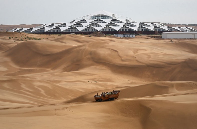
Beauty of Hotel In Inner Mongolia

A magnificent new hotel has bloomed amid the vast sea of sands in
Xiangshawan Desert, Inner Mongolia, 800 kilometers west to Beijing.
Named the “Desert Lotus Hotel”, the structure consist of repeating
triangular white tent tops, rotated 45 degrees and connected together in
a circular formation like a lotus. Free of tiles and bricks for
construction, the resort is built with low carbon environment friendly
materials to utilize solar, water and wind energy in the desert,
reducing environmental pollution and strengthening ecology protection.
Load bearing walls give the structure the bulk of its structural
integrity, while a dazzling array of repeating triangular panels provide
shade and protection from the harsh elements.


Due to the
restriction by its special geographic condition, PLaT Architects
invented a new structural system that fix in fluid sands using only
steel panels without the help of concrete or water. The panels and the
supporting skeleton structures are pre-fabricated, and make the base of
the building a large container for sands. Thus, the steel panel
structure can function as a boat floating on desert that carries the
building. The sands in and out of the structure exert same forces to
each other, and thus it is flexibly stabilized.


The hotel is part of a new resort built amid a vast sea of sand dunes,
increasingly popular with Chinese tourists. The resort hosts
Mongolian-themed performances, camel rides, desert surfing, and more.
source : Amusing Planet
Gisborne Airport: Runway With a Railway Crossing

Gisborne Airport is a small regional airport that is located on the
western outskirts of Gisborne, the East Coast of the North Island of New
Zealand. The airport is one of the very few airports in the world that
has a railway line intersecting the runway. The Gisborne airport which
covers a land of 160 hectares has three grass runways and one main
runway that is intersected by the Palmerston North - Gisborne Railway
Line. The Wynyard Airport, on Tasmania's north-western coast, also had a
railway crossing on the runway but declining rail traffic forced the
closure of rail traffic in early 2005, and thus the Wynyard airport rail
crossing is no more operational.


At Gisborne, on the other hand, the rail route functions actively and
so does the airport everyday between 6:30 in the morning and 8:30 at
night. After that, the runway is sealed off till morning. The railway
tracks splits the runway almost in the middle and very often trains or
aircraft are stopped until one of them moves on. It is a very
challenging task for the airport authorities to manage landing at the
intersecting runway along the operational rail route which has scheduled
departures and arrivals itself.
The airport
is a major link to enter the small region of Gisborne and hosts more
than 60 domestic flights. More than 150,0000 passengers fly through this
airport each year.
source : Amusing Planet